CHAPTER 6
Aboriginal Tribal TerritoriesBeing in a combined Sociology/Anthropology Department exposed me to ideas and information sources I might otherwise have missed. The separate studies reported in this chapter are due, in large part, to the influence of my then-colleagues in Anthropology, both faculty and students.The "Old Oregon Country" In the Spring of 1971 Ted Allen, an Assistant Professor in Anthropology, showed me a book[1] concerned with the Klamath Indians in south-central Oregon. It contained a map of the state showing aboriginal tribal territories at the time of Caucasian contact (the "ethnographic present"). What struck both of us was the similarity between that map and the present day one of county boundaries: smaller units near the coast, with larger ones inland.
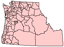
I might not have pursued the matter further except for an announcement by a graduate student, Steve Wright, that he was dropping out of the M.A. program. He said he was unable to complete a thesis. After questioning him about his efforts, I realized he had been advised to undertake projects too vast for completion in a doctoral program, let alone the masters. I suggested a simpler project: that he check with Ted about the map of tribal territories in Oregon and that he try to relate these to Indian population densities also from the "ethnographic present". He reluctantly, and then enthusiastically, undertook the study. He found that the Oregon map was part of a larger one by Schaeffer[2] showing tribes and language groups in the "Old Oregon Country", covering the same area as the Oregon Territory shown in Fig. 2-2. The tribal boundaries are shown in Fig. 6-1.
There were two areas which showed no tribal name. What these were (oversights?) we were unable to find out (Schaeffer had died). We included them in the study as "unlabeled area I" and "unlabeled area II". Another problem with the map was that some portions of tribal territories were arbitrarily lopped off by the outer boundary of the map itself. But since these territories lay in very arid country, no doubt lightly settled, such areas made arbitrarily small would do no damage to our test of the size-density hypothesis. Our next problem was to obtain information about the distribution of native populations. The obvious solution would be to obtain estimates of tribal populations, then compute the appropriate densities from these and our area estimates. No good population data was available. As Herb Taylor, then Dean for Faculty Research as well as Professor of Anthropology, had pointed out,
Even where data were available there was a problem of definition. What
one researcher recognized as a tribe, another might not. For example, in
the area around Bellingham, WA, Schaeffer's map distinguished the Lummi,
Nooksack and Samish tribes. Kroeber[5]
aggregated the Lummi and Nooksack populations, and Mooney[6] aggregated all three.
What is a tribe? I had a number of discussions and arguments with
colleagues about the meaning of the word[7] and whether the research question was
even legitimate (some argued that natives here didn't view territorial
boundaries the same way westerners did). Such arguments seem
metaphysical to me, not resolvable by any empirical means. In any case,
I was not an anthropologist while Schaeffer, Mooney, Kroeber and the
others were.
Sociologists have debated for years the definition of a "social system".
My view of such metaphysical disputes is more in harmony with the
physicists'[8]:
I had no way of asking people who had been dead for a century and a half
what those boundaries might have once meant to them. To me they were
boundaries which, once measured, would yield numbers for analysis.
In place of (unavailable) computed density figures, we used a portion of
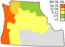
a map published by Kroeber[9] showing
average regional densities at the time of Caucasian contact. An
adaptation of that map is shown in Fig. 6-2.
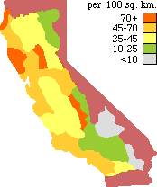
We projected Schaeffer's tribal map over Kroeber's density map and located each tribal territory in whatever density group characterized most of its area. This grouping in shown in Table 6-1. Kroeber's lowest density category (0.75-2 people per sq. km.) contained only the Northern Paiute and Shoshoni tribes. We combined this category with the next one for purposes of statistical analysis. We couldn't use regression analysis because the values of our independent variable were ranges rather than numbers. We couldn't use analysis of variance because the variances were not equal across our categories.[10] We used the nonparametric Kruskal-Wallis[?] test for analysis of variance by ranks, obtaining H = 30.6 with 4 degrees of freedom. As a result we, using the accepted ritual academic phrase, rejected the null hypothesis (p < .001). Let's face it: we showed support for the size-density one. We wrote up the results for publication, submitting the paper first, in April of 1972, to the American Journal of Sociology. They sat on it without response for over a year, finally rejecting the paper as "too anthropological" (whatever that means). We published it that June through a journal edited in our local Geography Department.[11] Africa During Christmas break 1971/2 an undergraduate, Lucky Tedrow, expressed interest in doing some research with me. It happened that Garland Grabert, an archaeologist in our Department, had just shown me a map (much too large to be reproduced here) showing tribal territories in Africa,[12] so I suggested a study of Africa to Lucky. He numbered the 838 tribal territories shown on the map and, using a table of random numbers, selected 100 of them for analysis. He measured each territory three times with the planimeter and averaged the results. He identified density categories for each tribe from their location on a regional density map.[13] His area estimates, within density categories, are shown in Table 6-2. The average areas within each density category are shown in Table 6-3.
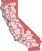
Average size declines monotonically with increasing density. Since there are five categories, and five things can be arranged in five- factorial ways, the number of possible outcomes would be 5! = 5*4*3*2*1 = 120 ways. The probability that our results arose through chance is one out of 120, p = 1/120 or.008. [14] A paper reporting these results was submitted to the Pacific Sociological Review and published in July of 1974.[15] California In Fall, 1972 I began working on a third cross-cultural study with another undergraduate student, Dave Myers. This was a direct replication of the study I had earlier done with Steve Wright. Our boundary map in this case showed tribal boundaries for California prior to 1770.[16] We excluded from this study any territories which bordered on the present state line (this is indicated by the shaded portion of Fig. 6-3). Planimeter measurements, transformed to square kilometers, are shown in Table 6-4. Density categories were again determined from Kroeber's map.
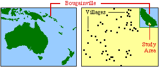
We used the Kruskal-Wallis test[?] and computed a value of H = 11.89. With 3 degrees of freedom, p{H=0} < .01. Had we used the same reasoning as in the Africa test, we would have found, for the four density categories, average areas of 39,252, 28,849, 12,596, and 7,930: four numbers with 4! or 24 permutations, only one of which fit the hypothesis. 1/24 = .04, so we could still reject the null hypothesis at p < .05. We submitted a report of this research to the Pacific Sociological Review; in May of 1973 it was rejected as "too anthropological" (that again). It ultimately appeared in Anthropology UCLA in Fall, 1974.[17] The Siwai of Bougainville Jay Callen was an undergraduate in our department when he and I were introduced by another of our Anthropologists, Professor Angelo Anastasio, in Spring, 1975. I worked on a number of projects with Jay, including this one concerning the Siwai, Bougainville Island. The Siwai are a Papuan-language group inhabiting the inland rain forest of southwestern Bougainville Island (155° E, 6° S) in the Solomon Islands. The ethnography on which we relied[18] covered the pre-war years 1938-9, when the Siwai were estimated to have a population of 4,700 people distributed over an eighty square mile area.
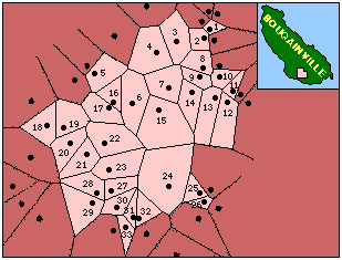
Oliver provided population figures for villages[19], but did not indicate the areas served by them. On the assumption that a point would be served by the village nearest it, we constructed Thiessen polygons[20] around each village as shown in Fig. 6- 5.
As can be seen, some of the polygons are bounded by the boundary of the study area itself; we excluded these from our study, numbering the remaining 33 villages for identification. We were unable to obtain a population figure for village #16, so it also was dropped from study. The area figures were estimated with a planimeter.
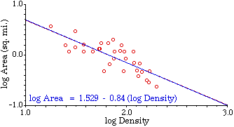
As Fig. 6-6 shows, there is a negative size-density slope for these polygons (r2 = .62; t0 = -6.923; p{β0} < .0005). The slope was not significantly different from the "world regession line" slope of -2/3 (t-2/3 = -1.410; p{β-2/3} = n.s.). We published our results through the Chicago Field Museum[21].
NOTES: [1] Theodore Stern, The Klamath Tribe: A People and Their Reservation, Seattle: University of Washington Press, 1966. [2] Claude Schaeffer "Indian Tribes and Languages of the Old Oregon Country: A New Map", Oregon Historical Quarterly, 60:129-133, 1959 [3] A large colored sheet of Schaeffer's map, produced by the Oregon Historical Society (Portland, no date). [4] Herbert C. Taylor, Jr., "The Utilization of Archeological and Ethnohistorical Data in Estimating Aboriginal Population," Bulletin of the Texas Archeological Society, 32:121- 39. 1961. [5] A. L. Kroeber, Cultural and Natural Areas of Native North America, Berkeley: University of California Press, 1939. [6] James Mooney, The Aboriginal Population of America North of Mexico, Smithsonian Institution Miscellaneous Collections, Vol. 8, No. 7., 1928. [7] June Helm (editor), Essays on the Problem of Tribe (Proceedings of the 1967 Annual Meeting of the American Ethnological Society), Seattle: University of Washington Press, 1968. [8] Henry Morgenau and George Moseley Murphy, The Mathematics of Physics and Chemistry, (2nd edition), 335, Princeton: D. Van Nostrand Company, 1956. [9] A. L. Kroeber, Op. cit., 154. [10] by Bartlett's test, in A. Hald, Statistical Theory with Engineering Applications, 190-1, New York: Wiley, 1952. [11] G. Edward Stephan and Stephen M. Wright, "Indian Tribal Territories in the Pacific Northwest: A Cross-cultural Test of the Size-Density Hypothesis," Annals of Regional Science, 7:113- 23, 1973. [12] George P. Murdock, Africa: Its Peoples and Their Cultural History, New York: McGraw-Hill, 1959. [13] Else Schmidt and Paul Mattingly, Population Density in Africa about 1960. Berlin: Georg Westermann Verlag, 1966. The original map showed 9 density categories, from "uninhabited" to "> 160 per sq. mi." These were so fine that he had difficulty locating tribes, so we collapsed several categories into those shown in Table 6-2. [14] This tidy little "test of significance" was suggested by Professor Charles Gossman, a sociologist in our Department. [15] G. Edward Stephan and Lucky M. Tedrow, "Tribal Territories in Africa: A Cross-cultural Test of the Size-Density Hypothesis," Pacific Sociological Review, 17:65-9, 1974. [16] R. F. Heizer and M. A. Whipple, "Map of Native Tribes, Groups, Dialects and Families of California Prior to 1770", The California Indians, :frontispiece, Berkeley: University of California Press, 1971. [17] David E. Myers and G. Edward Stephan, "Tribal Territories of the California Indians," Anthropology UCLA , 6:59:65, 1974. [18] Douglas L. Oliver, A Solomon Island Society, Boston: Beacon Press, 1967. [19] ibid, p. 16. [20] Thiessen polygons: These are a set of polygons (aka the Dirichlet Tessellation or the Voronoi Diagram) which enclose the area geographically closest to a defined central place (among a set of such central places); conversely, any point is included in the polygon surrounding the central place nearest it. We obtained the straight lines comprising the polygons by connecting intersections of circular arcs drawn with equal radii from adjacent villages. Peter Haggett, Locational Analysis in Human Geography, 247, London: Edward Arnold Publishers, 1965 cites examples of the use of Thiessen polygons by the U.S. Weather Bureau to regionalize the rainfall reports of local weather stations, and by Donald Bogue to determine the boundaries of metropolitan regions in the United States. [21] Jay S. Callen and G. Edward Stephan, "Siwai Line Villages: Thiessen Polygons and the Size-Density Hypothesis", Solomon Island Studies in Human Biogeography, Number 4, Chicago: Field Museum of Natural History, 1975. | |||||||||||||||||||||||||||