CHAPTER 1
Variation in County SizeOnce upon a time....Fall quarter of 1968 at the University of Oregon, I was trying to settle on a topic for my doctoral dissertation in Sociology. My advisor, Theodore Anderson, had seen me through a half-dozen promising starts, each of which I abandoned as the initial curiosity, more or less satisfied, gave way to the less interesting and therefore tedious work of writing up the results. My despair over ever settling on a suitable topic led me at one point to a half-hour's pacing the perimeter of my backyard in a cold rain, which I quit doing when I noticed that Zorba, Nancy, Vivian and Angus (my dog and three cats) were trailing along dutifully behind me. The research reported here began with what I thought would turn out to be another false start.
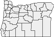
We thought it might be useful to study resistance to the sort of change Durkheim envisioned. What factors tend to maintain or retain established territorial divisions in spite of the assumed erosive tendencies? We narrowed the topic: specifically, what factors were associated with Oregon voters' resistance to consolidation of school districts? The introduction of the school bus in the 1930s and '40s had clearly led toward consolidation of smaller rural districts, as Durkheim would have predicted. But resistance varied from district to district and could prove an interesting topic of study. While we were looking at vote counts and general population characteristics of Oregon counties, displayed in maps produced by the office of the Secretary of State, Professor Anderson remarked how large the counties were in the southeastern part of the state (see Fig. 1-1). One of us wondered Why? and I was challenged to answer that question by our next meeting.
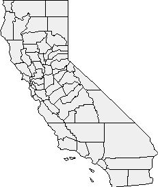
As I left Professor Anderson's office I thought about the only other state in which I had lived, California (Fig. 1-2). The large counties there lay at the extreme north and south ends of the state. To put it the other way around, the smaller counties lay in the old "gold rush country" between San Francisco and Reno.
What could northwestern Oregon and this part of California have in common? One similarity which occurred to me was that each contains the state capital, the location of the legislatures which created the counties in the first place. I formulated this "size-distance" relationship: county SIZE varies directly with DISTANCE from the state capital. The greater the distance, the larger the county. As it happened, I had just been reading a Human Geography textbook assigned for an undergraduate course taught by Professor Anderson. It contained a possible explanation for the size-distance relation:
we may regard nearby areas as strongly differentiated and remote areas as uniform, a view reinforced by the curvilinear relations of traveling costs to distance.[2]
We don't need to introduce the economic considerations: the
fact is that we do make finer territorial distinctions in our "mental
maps" the closer we are to home. When I lived in San Francisco I made
fairly fine territorial distinctions with regard to neighborhoods: "the
Haight", "Fillmore", "Castro". I might refer to a location in the
surrounding Bay Area as "East Bay" or "up in Marin [county]" or "down the
Peninsula". More distant entities might be "southern California", "the
South", "Latin America".
The problem of county size hardly seemed to deserve serious attention. I
had arrived at the size-distance generalization by the time the elevator
had taken me from Anderson's office on the eighth floor down to mine in
the basement. I got the quote and citation from Haggett's text as soon as
I reached my desk. I immediately returned to the eighth floor to inform my
mentor that another potential topic, if that was what he intended, was
dead. It looked as though I would be making another stroll around the
backyard.
Professor Anderson grinned as I bragged about the ease and speed with
which I had dispatched the county size problem — empirical
generalization and theoretical explanation in the time it took to ride to the basement!
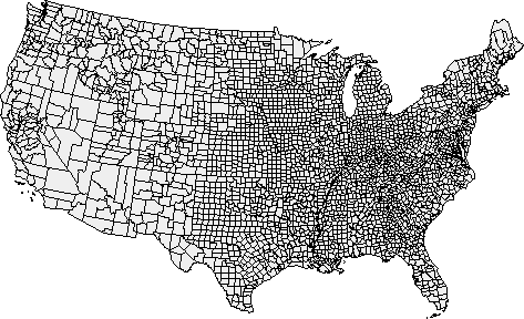
While I was bragging, he was rolling out a large county outline map of
the United States (see Fig. 1-3), suggesting that I carefully examine
some states other than Oregon and California.
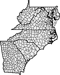
In particular, he called attention to several Southern states (Fig. 1- 4). These showed counties with little variation in size, counties which were in fact uniformly small. Since the dependent "variable" size was approximately a constant, the independent variable distance was irrelevant. The size-distance relation was dead, not because I was bored with it but because it didn't exist.
Well, there was a size-distance relation in Oregon and California. and apparently in such states as Maine (distance from Augusta), Florida (Tallahassee) and Utah (Salt Lake City). And there wasn't a size-distance relation in the South (and also, it appeared, in much of the Midwest). Perhaps the variable to be investigated ought to be the degree to which the size-distance relation existed: Why was it present in some states and not in others? It had to be part of some larger picture of variation in county size.
I found a table of states[3] showing county size within each state (Table 1-1). From it I developed a rough typology of states with regard to county size. I wanted to see if this suggested any new approaches.
It became evident that, at least to some degree, there was both an
historical and a geographic pattern to the typology. In general, the
eastern and older states were in the small-county categories. Western
and newer states were in the large-county ones. It occurred to me that
county government might have functioned differently from one region or
time period to another, so I next looked into the development of the
county government system in the United States.
GROWTH OF COUNTY GOVERNMENT
I was surprised to find how little had actually been written about the
development of county government. The works I consulted[4], while hardly exhaustive, all tell pretty
much the same story. They each begin with a distinction between two types
of local government during colonial times, the one based on the town as
the fundamental unit, the other based on the county. The former is
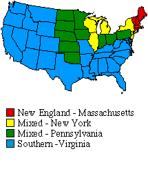
referred to as the "New England" or "Massachusetts" type, the latter as
the "Southern" or "Virginia" type. There are several intermediate types.
What follows is a brief summary of the development of these types.
Southern Type
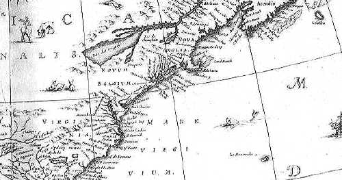
The first counties in North America were formed in Virginia in 1634. The
settlers there, finding a mild climate and fertile soil, came rapidly to
depend upon agriculture and tobacco exports for subsistence. Tobacco
cultivation produced a plantation system of settlement in which towns
generally failed to develop in spite of government efforts to stimulate
their growth. Governmental power, originally concentrated in the
Governor and Council of the Virginia Company at Jamestown, was gradually
decentralized. In 1618 "monthly courts" were held in the outlying
plantations. In 1619 "incorporations," special units of military
organization, were formed in outlying areas. By 1631 the jurisdiction of
the monthly courts generally coincided with those of the incorporations,
thus fusing judicial and police functions. Parishes, which performed
both religious and civil functions, served as subdivisions of these
larger districts.
A host of tasks was assigned to the county, from the construction and
maintenance of roads to the regulation of taverns, and from workhouse
construction to ridding the region of wolves. Several counties supported
free schools. By 1700 the counties of Virginia, source of the "Southern
type", were performing most of their present-day functions. What
remained in their development was a further proliferation of offices,
paid rather than honorary officials, and an increased complexity of
organization.[5]
New England Type
The New England type, in contrast, emphasized the town over the county
in matters of local government; the county performed few functions other
than its minimum assignment, the administration of justice. The settlers
in New England found a severe climate and rocky soil; they turned to
fishing and shipping for sustenance. In contrast to the Anglican
settlers in Virginia with their diocesan or regional form of church
governance, the New Englanders had a congregational form of
organization, and they settled in towns rather than on scattered
plantations.
Middle or Mixed Type
The "Middle" type refers to the kind of local government developed in
New York and Pennsylvania. While there were some differences between the
two states, in general it can be said that they represented a blend of
the Southern and New England types. The county boards handled functions
beyond the administration of justice, but the constituent towns also
played important roles.
In New York, under the Dutch West India Company, large tracts of
land could be secured by the patroons if a colony of fifty persons or
more could be established; these landholders exercised decentralized
governmental powers over their estates. After conquest by the English,
towns were recognized in 1665 as the basic unit of local government, but
judicial districts called "ridings" were established; These comprised
several towns and were presided over by a sheriff. Actual counties, with
justices exercising judicial and administrative functions, were
established in 1683. A board of supervisors was established (one elected
from each town) in 1691 to levy taxes for local purposes. The
administrative functions of the justices were gradually transferred to
this body.
The result of these developments is that the towns in New York (which
had their own elected supervisors, clerks, constables, assessors,
surveyors and overseers of the poor) were more important than were those
of Virginia; and the counties, with their boards of supervisors,
exercised more administrative authority than did the county courts of
the Massachusetts variety.
The so-called "commissioner system" of Pennsylvania was similar
to the "supervisor system" of New York. Counties were formed there in
1682; unlike New York, towns had not developed very fully. In 1726 the
responsibility of the justices for taxation was taken by a board of
three commissioners, elected at large. As in New York, this board
gradually assumed all non-judicial administrative duties. Later, as
towns became more significant in Pennsylvania, borough government were
developed for them.
The Southern type of local government came into general use throughout
the southern Colonies; the New England pattern prevailed in the region
of that name; and the Middle pattern was found in New York, New Jersey,
Pennsylvania and Delaware. Fig. 1-6 shows the diffusion of these basic
patterns through the rest of the United States. In general, diffusion
reflects the patterns of westward migration, although the Southern type
came to predominate through the Far West (independent of migration
patterns). South Carolina technically had no counties until
Reconstruction in 1868; it was governed by very large districts called
"ridings". There were unique early forms of local government in such
states as Florida, Louisiana, Texas and California, owing to Spanish,
French and Mexican influences; but the patterns finally adopted were
those indicated in Fig. 1-6 [6].
Conclusion?
After reviewing this development I was in a position to determine
whether differences in function accounted for the distribution of the
states shown in the typology developed earlier. The answer, as shown in
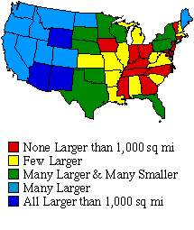
comparing Fig. 1-5 with Fig. 1-6, was that differences in type of local
government were unrelated to variation in county size.
The "Southern type" includes one of each of the five typology categories: Kentucky (none larger), Missouri (some larger), Oklahoma (many larger, smaller), California (many larger), and Arizona (all larger). The "New England type" includes Vermont (none larger), New Hampshire (some larger), and Maine (many larger, smaller). Clearly, type does not predict size. "Many larger" includes Maine (New England), North Dakota (Mixed) and Colorado (Southern). "None larger" includes Connecticut (New England), Ohio (Mixed), and Georgia (Southern). So the converse is also true: size does not predict type. The size-TYPE relation was no more tenable than the earlier supposed size-DISTANCE relation. Explaining county size remained a problem.
Notes: [1] Emile Durkheim. The Division of Labor in Society. Translated by George Simpson. Glencoe: The Free Press. 1964(1893). [2] Peter Haggett, Locational Analysis in Human Geography, 38, London: Edward Arnold. 1965 (emphasis added). [3] William Anderson, The Units of Government in the United States: an Enumeration and Analysis, 24, Chicago: Public Administration Service. 1945. [4] Some of the principal ones were: Herman G. James, Local Government in the United States. New York: Appleton. 1921. Kirk H. Porter, County and Township Government in the United States. New York: Macmillan. 1922. John A. Fairlie and Charles M. Kneier, County Government and Administration. New York: Century. 1930. Arthur W. Bromage, American County Government. New York: Sears. 1933. Lane W. Lancaster, Government in Rural America. New York: Van Nostrand. 1937. Paul W. Wager, County Government Across the Nation. Chapel Hill: University of North Carolina. 1950. [5] see Albert Ogden Porter, County Government in Virginia: A Legislative History, 1607-1904. New York: Columbia University Press. 1947:342 for a table showing the growth in organizational complexity. [6] adapted from John A. Fairlie and Charles M. Kneier, County Government and Administration, 109, New York: Century. 1930. Note: several midwestern states show two types of local government in the same state; two counties in Washington State (Whatcom and Spokane) were of the Mixed (Pennsylvania) type. | |||||||||||||||||||||||||||||||||||||||||||